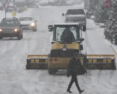


New York declared a state of emergency early Thursday morning as the Northeast region was slammed by torrential rain from the remnants of Ida, causing heavy flooding and reports of numerous water rescues.
In New York City, a travel ban was implemented until 5 a.m., according to an emergency alert sent by Notify NYC. All non-emergency vehicles must stay off the road, the alert said.
Almost all the city subway lines were suspended due to the flooding. The Metropolitan Transit Authority website said that only the “7” line and the Staten Island Railway were operating with delays.
“We’re enduring an historic weather event tonight with record breaking rain across the city, brutal flooding and dangerous conditions on our roads,” New York Mayor Bill de Blasio said on Twitter.
“We will have a tough few hours coming up until we get the rain out of here,” de Blasio told CNN affiliate WCBS. “I have never seen this much rainfall this quickly. It is absolutely astounding … We are talking three inches, four inches in an hour. Unbelievable accumulation.”
New York Gov. Kathy Hochul told CNN the rain was “far more than anyone really expected,” and left the region in “a very dire situation.”
“We can take all the precautions in advance, and we did deploy our assets to be on the ground in anticipation, but mother nature will do whatever she wants, and she is really angry tonight,” Hochul said.
The National Weather Service in New York urged people to stay off the roads. “We are seeing way too many reports of water rescues and stranded motorists. Do not drive through flooded roadways. You do not know how deep the water is and it is too dangerous,” the weather service said.
Rescuers have been removing people from flooded roadways and subways across New York City, the New York Fire Department said Thursday morning.
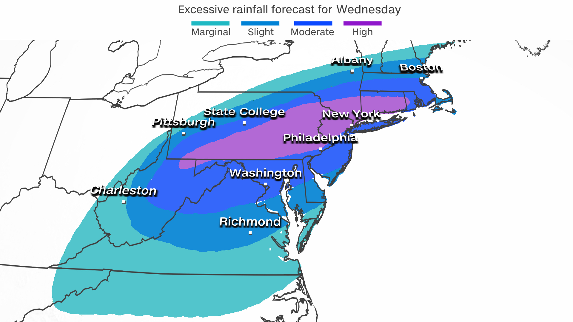
At least five flash flood emergencies were issued Wednesday evening by the National Weather Service, stretching from just west of Philadelphia through northern New Jersey. Dozens of water rescues were taking place and numerous roads have been closed.
In New Jersey, Gov. Phil Murphy also declared a state of emergency, urging residents to “stay off the roads, stay home, and stay safe.”
The latest flash flood emergency included Newark, the state’s largest city. Rainfall estimates for parts of central and eastern Pennsylvania and New Jersey ranged from 4 to 8 inches of water with some isolated locations approaching 10 inches. Some parts saw 3 to 4 inches of rain an hour throughout Wednesday evening.
“Five inches of rain just doesn’t happen in this region very often,” said CNN meteorologist Brandon Miller. “We could easily see some deadly flash floods like we saw in Tennessee last week.”
A flash flood emergency was also issued for New York City and extended until 3 a.m. ET, according to the weather service, covering Manhattan, Queens, the Bronx and areas as far north as White Plains. The area has already seen between 2 and 3.5 inches of rain in just several hours and rainfall rates are expected to be as high as 3 to 5 inches an hour for the rest of Wednesday.
Heavy rainfall will also continue in northern New Jersey and eastern Pennsylvania for the rest of Wednesday evening, while overnight impacts will continue in southern New York, stretching into Connecticut, Rhode Island and Massachusetts.
A person died due to flooding in the Guesses Fork area of Hurley, Virginia, the Buchanan County Sheriff’s Office said. People were asked to stay away from the area, according to the sheriff’s office, and only residents who showed ID proof and authorized personnel were allowed to enter Wednesday night.
In Maryland, one person died and another is missing after the remnants of Ida flooded an apartment complex Wednesday, Montgomery County officials said. The 19-year-old man was found dead but the cause has not been confirmed, Montgomery County Police spokesperson Casandra Durham told CNN.
Fire and rescue personnel evacuated dozens of people from the Rock Creek Woods apartment complex in Rockville, officials said. About 150 residents were displaced after 50 apartments were impacted and 12 flooded, police said.
A tornado touched down in a primarily commercial area of Annapolis on Wednesday afternoon, fire department spokesperson Bud Zapata said. No injuries have been reported but some private residences were damaged and there is an active gas leak in the area, Zapata said. Maryland Gov. Larry Hogan said on Twitter his office was working with city and county officials to assess the damage.
Power outages were reported throughout the region as the severe weather moved through. More than 109,000 customers in Pennsylvania were in the dark Thursday morning, according to PowerOutage.us. More than 87,000 outages were reported in New Jersey along with more than 37,000 in New York.
Ida made landfall in Louisiana on Sunday as a Category 4 hurricane, and though it has weakened significantly since, it has still dropped heavy rain across the Southeast on its way north. More than 60 million people are under flash flood watches for parts of the central Appalachians, mid-Atlantic, and into southern New York and southern New England.
41 people rescued from school bus trapped in floodwaters
About 41 passengers were rescued from a school bus trapped in floodwaters from the remnants of Ida on Wednesday morning in Shaler Township, Pennsylvania, officials said.
Local police and fire officials responded to the school bus headed for Shaler Area High School and supervised the evacuation of those on board, Shaler Area School District spokesperson Bethany Baker said in a statement.
The Cherry City Volunteer Fire Company said it performed a water rescue by boat at approximately 6:50 a.m., and evacuated every passenger on the bus without injury.
The school district canceled school for elementary and primary students due to rain and “worsening road conditions,” according to a Facebook post on Wednesday morning. Middle and high school schedules proceeded as usual. The rescued students were transported safely to high school, Baker said.
Following reports of an uncontrolled release from Pennsylvania’s Wilmore Dam, causing flash flooding downstream of the dam, the National Weather Service issued a flash flood emergency — the highest level of threat. The nearest town downstream from the dam is Wilmore.
A flash flood emergency also was issued for Montgomery County, just north of Philadelphia, the National Weather Service said. Flash flooding has already begun Wednesday evening and more than 30 water rescues are taking place across the county, the weather service said.
Rainfall amounts of 3 to 4.5 inches have been reported while another 1.5 to 3 inches were expected over the next few hours.
“This is an extremely dangerous storm that is impacting the entire state. As we continue to monitor the conditions, I ask everyone to please stay home if you’re able,” Gov. Tom Wolf said in a statement on Wednesday, urging residents to take the storm seriously.
Wolf later said he was sending emergency resources to Bucks County to provide support following severe weather in the southeastern part of the state.
National Guard high water vehicles, an urban search and rescue team, and two swift water emergency response teams were dispatched, Wolf said in a statement.
Threats of potentially catastrophic tornado damage
It’s not just the flooding that’s worrying officials — it’s tornadoes, too.
And a tornado watch was issued for the Northeast, which includes portions of northern New Jersey, southern New York and Connecticut. The watch, which includes New York City, lasts until 1 a.m. ET.
A tornado watch is also in effect until 7 a.m. ET for parts of Massachusetts and Rhode Island, the weather service said.
Just before 6:30 p.m. ET on Wednesday, a confirmed tornado was located about 11 miles southwest of Gloucester, New Jersey, and was moving northeast at 40 mph.
Videos captured in Mullica Hill in South Jersey showed debris twisting up in a tornado.
“I looked out my driver’s window and saw the swirling clouds and debris flying toward me,” Kristi Johnston, who recorded the videos, told CNN. “I rolled my window down and it sounded like a train coming. I hung up on my husband and started to drive away from it. It was extremely scary.”
In Newark, New Jersey, the air traffic control tower at Newark Liberty Airport was briefly evacuated due to wind Wednesday night, the Port Authority of New York and New Jersey said in a statement to CNN. Personnel have since returned to the tower but the airport is under a ground stop, according to the FAA’s website.
The lower level of Terminal B at Newark flooded and passengers were moved to upper levels of the terminal, the Port Authority said.
Similarities between Hurricanes Ida and Camille
“There are certainly a lot of similarities with Ida and Camille more than 50 years ago,” Miller said.
“Both storms formed in the same spot, hit near the same spot and both have a similar trajectory over the Northeast. Camille’s floods in the northeast were deadly.”
That storm brought up to 27 inches of rain to portions of the mid-Atlantic, leading to rising rivers sweeping through Virginia towns.
Camille first hit the US as a dangerous Category 5 hurricane along the central Gulf Coast in August 1969.
The storm followed a path very similar to Ida through Tennessee, Kentucky and off the mid-Atlantic coast.